 AI Tools Review Editorial Team
Quick Answer:
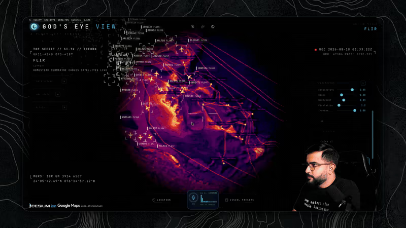
God's Eye View is an MIT-licensed browser application by Bilawal Sidhu - ex-Google AR and 3D-mapping product manager, now technology curator and host at TED - that fuses roughly fifteen live public data feeds onto a photorealistic 3D globe. Aircraft, ships, satellites, earthquakes, traffic, wildfires, transit, bikeshare and city CCTV, rendered through CRT, night-vision and thermal sensor styles, and driven by an OpenAI Realtime voice agent with 28 tools that can fly the camera, annotate the map and answer questions about what is on screen. It runs with no API keys at all on a reduced feed set, open-sourced on 24 August 2026 after a public poll of his audience. It deliberately has no face recognition and no person search.
The thing that makes God's Eye View unsettling is not the interface, though the interface is doing a lot of work. It is that nothing on the screen is simulated. Every aircraft, every ship, every satellite ring and every traffic camera is a public feed that has been sitting there, freely available, for years - waiting for someone to put them all in the same window.
This is a full review of what it does, what it runs on, where the data comes from, and what it means that this capability now takes one npm install.
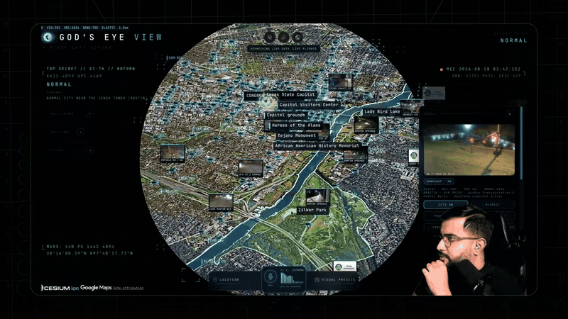
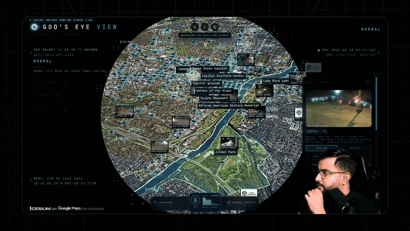
Sidhu demonstrates the traffic and public-camera layers, and how the voice agent moves between them.
Executive Summary
God's Eye View began as a YouTube series that accumulated more than five million views, in which Sidhu flew around a photorealistic globe layered with real-time open data. The demand to actually use the thing became loud enough that he put the question to his audience and then released the client as open source.
What makes it worth writing about is not any single component. Every feed it consumes is public; CesiumJS has rendered 3D globes for a decade; OpenAI's Realtime API is available to anyone. The contribution is integration - the unglamorous, genuinely hard work of making fifteen incompatible feeds agree about time, position and altitude, and then putting a natural-language interface on top so that you do not need to know which layer holds the answer.
- Best for: OSINT practitioners, journalists, aviation and maritime enthusiasts, geospatial developers, and anyone who wants a serious CesiumJS reference implementation.
- Headline facts: MIT licence, roughly fifteen live feeds, 11,000+ live aircraft via OpenSky, an 838-object satellite catalogue, 28 voice tools, and a measured 1.86-second median cold start on one M5/Chrome capture.
- Defining trait: it makes the sheer volume of freely-available public telemetry viscerally obvious in a way no spreadsheet ever could.
- Main caveat: it is explicitly an exploration and learning client, not a hardened production service, and its own documentation says not to use it for anything operational.
What It Actually Is
Sidhu's own description is "a spy satellite simulator in your browser, except the data is real". That is accurate but undersells the interaction design. The application is less a map than a cockpit.
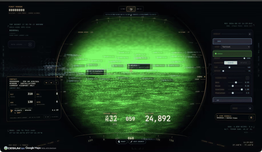
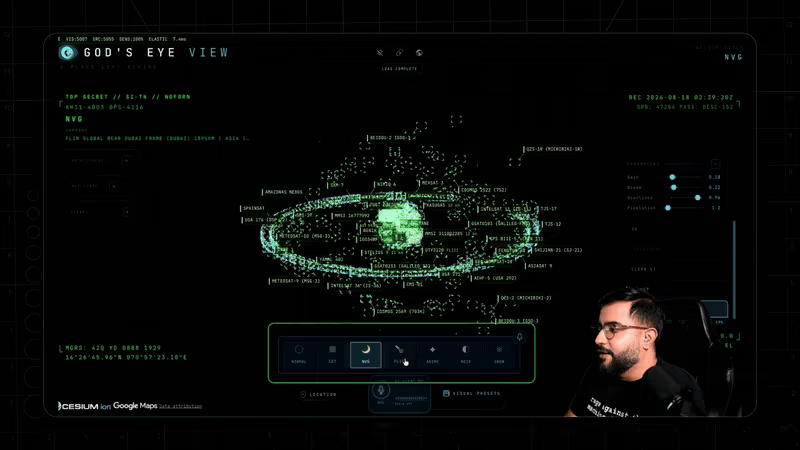
You can enter a cockpit mode that rides a live aircraft with terrain collision, maintaining a 250km contact roster of nearby aircraft and vessels. You can switch sensor styles - CRT, night vision, FLIR thermal, Noir, Snow - which are not merely cosmetic filters but different ways of reading the same scene, the way a thermal view makes cable routes legible where a satellite view does not. You can drop persistent vector annotations, run a scene director for cinematic camera tours, and serialise the entire view state into a share link.
The result is an application that rewards exploration rather than queries. You do not go to it with a question so much as you fly around until the question occurs to you - which, for a tool whose subject is "what is happening on Earth right now", turns out to be the right interaction model.
The Data: Fifteen Public Feeds
The data table in the project's README is the most educational part of the repository, and it is worth reproducing in substance because it is an inventory of what the world publishes about itself for free.
- OpenSky Network - 11,000+ live aircraft with routing, refreshed every 15-30 seconds. Anonymous access works; OAuth raises your credit allowance.
- adsb.lol - military ADS-B traffic, free and live.
- AISStream - global ship positions, live, free signup.
- CelesTrak - an 838-object satellite catalogue, propagated locally with SGP4.
- USGS - seismic events on a rolling 24-hour window, real-time.
- TomTom - live traffic flow speeds, metered beyond a free tier.
- City APIs - public CCTV across ten regions, continuous.
- Radio Browser - 750+ geolocated radio stations you can actually listen to.
- GTFS-Realtime - public transit in seven cities, 30-second updates.
- GBFS - live bikeshare availability.
- NASA FIRMS - active fire detections, daily.
- Launch Library 2 - a rolling 30-day space mission catalogue.
- Esri, Google Maps, Cesium ion, OpenStreetMap - basemap imagery, photorealistic 3D tiles, terrain and bundled infrastructure geometry.
On top of the live feeds sit three bundled static datasets that are, in their own way, the most striking layers in the application: 4,351 datacentres, 704 dams and 712 submarine cables. Turn all three on at once and you are looking at a map of where modern civilisation is physically load-bearing.
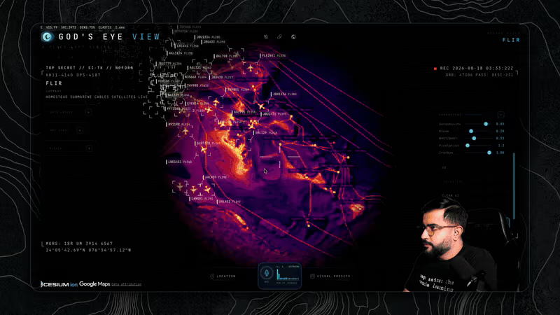
None of this is leaked, scraped or obtained. ADS-B is broadcast by aircraft because aviation safety requires it. AIS is broadcast by ships for collision avoidance. Satellite elements are published by CelesTrak, seismic data by USGS, traffic camera feeds by the cities that operate them. The entire application is an argument about aggregation: each feed is innocuous, and the composite is not.
Matt Wolfe's walkthrough of the project and what it reveals about the volume of public telemetry.
The Voice Agent and Its 28 Tools
The voice layer is built on the OpenAI Realtime API, and its 28 tools divide into four jobs that map neatly onto four human roles.
- Camera control - the drone pilot. Navigate to a location, orbit it, zoom, reset. These are the verbs that turn a spoken place name into a shot.
- Annotations - the whiteboard. Draw boundaries, measure distances, label infrastructure, drop persistent pins.
- Queries - the analyst. Count entities, filter by attribute, make temporal predictions about what is on screen.
- Operations - the console. Toggle layers, switch sensor styles, adjust detection density.
This is a textbook example of tool design done properly, and it is instructive well beyond geospatial work. The tools are narrow, verb-shaped and composable; the model is not asked to reason about Cesium's camera mathematics, only to choose which of 28 well-defined actions matches the request. It is the same architectural instinct behind TypeSafe's System One decomposition: give the model small, typed decisions and let deterministic code do the rest.
Cost is metered by minute of active voice session. Sidhu notes that the mini model works and the standard model is recommended, with a $5 hard session cap built in - a small but telling detail about designing consumer-facing AI features where a runaway session is a real risk.
Architecture and Engineering
The stack is deliberately unfashionable: vanilla JavaScript with no framework, CesiumJS 1.x for the globe, Vite for the build. For an application whose bottleneck is GPU rendering and feed reconciliation rather than component state, that is a defensible choice, and it makes the repository unusually readable as a reference implementation.
The flow runs src/main.js to bootstrap, ui.js for runtime interface, per-layer modules under data/, the Realtime agent and its tools under voice/, and the cinematic director under scenes/. A server-side proxy brokers credentials for OpenAI, AISStream, OpenSky OAuth and camera frames, with SSRF protection, response caps, sanitised errors and environment-variable throttling - which is more security hygiene than most hobby projects and, given how credential-adjacent surfaces get exploited, entirely warranted.
Four engineering details are worth calling out because they are the difference between a demo and something usable:
- World-stable icons. Screen-space heading projection keeps an aircraft's true course readable from any camera angle, rather than letting icons spin as you orbit.
- Interpolated motion. Feeds arrive every 15-30 seconds; dead reckoning bridges the gaps, accepting one interval of lag in exchange for smooth motion instead of teleporting contacts.
- SGP4 satellite propagation. Orbit rings are realigned via GMST so they do not drift over a long session - the kind of correctness detail that only shows up if you leave the tab open.
- Request budgeting. An OpenSky credit governor, a TomTom daily tile budget and disk-cached TLEs keep free tiers from being burned in an afternoon.
Performance is quoted carefully: a point-in-time M5/Chrome capture measured a median 1.86-second cold start, presented explicitly as a comparison baseline rather than a guarantee, with methodology in the repository's performance documentation. That is the right way to publish a number, and a standard more vendors should meet.
Why the Spy-Thriller Aesthetic Matters
It would be easy to dismiss the CRT scanlines, the "TOP SECRET" chrome and the night-vision green as styling. They are doing something more interesting than that.
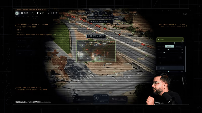
The visual grammar is borrowed wholesale from films in which a government agency watches everything, and that borrowing is the argument. When you see public ADS-B data presented as a spreadsheet, it reads as aviation trivia. When you see the same data through a simulated reconnaissance sensor, your instinctive response is that someone should not be able to see this - at which point you have to sit with the fact that anyone always could.
Sidhu has framed this elsewhere as the end of the intelligence monopoly, and whatever you make of that phrase, the demonstration is effective. The aesthetic does not exaggerate the capability. It calibrates your reaction to a capability that was already there and that the plain presentation had been quietly anaesthetising.
Running It Yourself
Setup is genuinely straightforward. You need Node.js 24.14.0 or later, or 26.x - note that version 25 is unsupported because it is end-of-life - and then npm ci, npm run doctor and npm run dev, which serves at localhost:4173. There is also a one-click install via Pinokio 8.2+ on Windows, macOS and Linux, which handles locked dependencies for you.
The key design decision is that every API key is optional, added through an in-app panel rather than a config file. With no keys at all you still get Esri satellite imagery with OpenStreetMap fallback, flights from adsb.lol, military traffic, satellites, earthquakes, public cameras, radio, transit, bikeshare, fire detections and space missions. That is a remarkably complete experience for zero configuration and zero cost.
Keys then unlock tiers: Cesium ion's free community tier for 3D cities and world terrain (personal and non-commercial use), Google Maps for direct photorealistic 3D tiles and place search (metered, billing required), OpenAI for the voice agent and AI heads-up summary (metered, a few cents per active minute), and free tiers for AISStream ships, NASA FIRMS fires and TomTom traffic. Optional OpenSky and Launch Library 2 keys simply raise polling allowances.
The project is maintained by Sidhu with Sameh Khamis of Halfpixel, and each data source carries its own separate terms documented in the repository - worth reading before you build anything on top of it.
The Decision to Open-Source It
The release was not a foregone conclusion, and Sidhu handled the decision unusually transparently: he put it to his audience as a poll, describing himself as "honestly torn - open source ethos vs. actually building a sustainable product/business out of this".
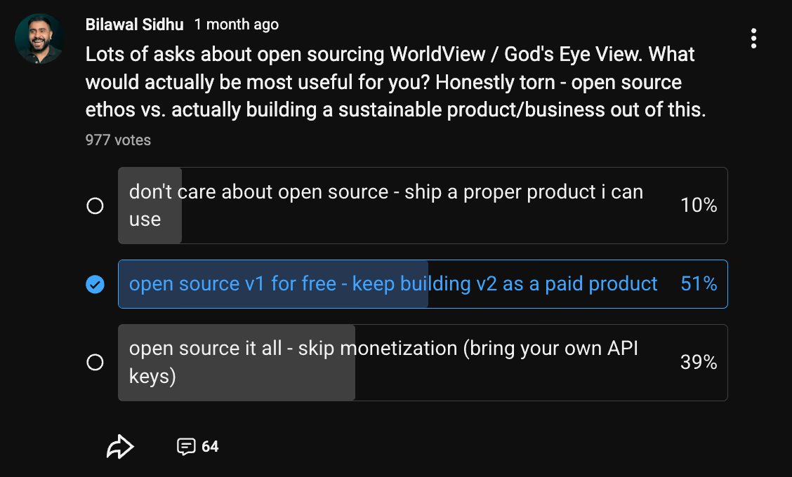
The result across 977 votes was instructive: 51% wanted v1 open-sourced free with v2 as a paid product, 39% wanted the whole thing open-sourced with users bringing their own API keys, and only 10% said they did not care about open source and just wanted a finished product. Ninety per cent of an audience that had watched millions of views of a polished demo preferred the source over the product.
What shipped on 24 August 2026 was the more generous of the two open options: the full client under MIT, bring your own keys. The project subsequently reached the top of GitHub Trending, which suggests the audience was not merely expressing a preference politely.
The Privacy Question, Honestly
An application that puts live CCTV, aircraft and vessel tracking in one window invites an obvious objection, and it deserves a straight answer rather than a defensive one.
The strongest point in the project's favour is a design boundary drawn explicitly in the documentation: no named-person search, no face recognition, no individual tracking features. That is not incidental. Those are precisely the capabilities that would convert a public-data aggregator into a surveillance instrument, and they are precisely the capabilities that would be most technically straightforward to add. Their absence is a decision, and it is the right one.
The honest counter-argument is that aggregation is itself a capability. A single ADS-B feed tells you a plane is at a location. ADS-B plus AIS plus public cameras plus traffic flow plus a voice agent that can answer "what military aircraft are near this port right now" is a different thing, even though every input is public. The privacy literature has a name for this - the mosaic effect - and it is why intelligence agencies have always treated open-source collection as collection rather than as reading the newspaper.
Where that leaves you depends on a judgement about counterfactuals. This capability existed before the release; what changed is who can run it. Nation-states, defence contractors and well-funded firms have had exactly this for years. Open-sourcing it does not create the capability, it redistributes it - to journalists, researchers, hobbyists and anyone else, including people you would rather not have it. That is the standard open-source security bargain, and God's Eye View is a clean instance of it: the asymmetry it removes was an asymmetry of access, not of possibility.
One further note that cuts in the project's favour: by making the volume of public telemetry legible, it materially improves the public's ability to have an informed argument about what should be public. It is difficult to debate ADS-B privacy policy when almost nobody understands what ADS-B discloses.
Limitations and Disclaimers
The documentation is admirably blunt about what this is not, and the warnings are substantive rather than legal boilerplate.
- Not for operational use. The project states directly that it should not be used for flight or maritime navigation, emergency response, medical or health decisions, investment decisions, or anything else safety-critical. Verify against authoritative sources.
- Data may be wrong. Feeds may be delayed, incomplete, modelled, inferred or simply incorrect - an inherent property of aggregating public telemetry.
- Camera positions are estimates. CCTV poses are described as "estimated priors" calibrated by manually dragging a gizmo. They are approximate by construction.
- Trajectories are reconstructions. Space mission paths are labelled "RECONSTRUCTED ESTIMATE" in the interface itself, which is the honest way to render a model.
- Not a hardened service. It is described as an evolving open-source client for exploration and learning, with a documented threat model covering LAN sharing and provider quota enforcement.
Practically, the constraints most users will hit first are quota-related. The free tiers are generous but finite, and a long session with traffic and photorealistic tiles enabled will consume them. The request budgeting helps, but it is a mitigation, not a solution.
What It Signals
Three trends converge in this repository, and it is a useful marker for all of them.
First, spatial intelligence is becoming an application category rather than a research topic. The same month that saw this release also saw continued work on world models and 3D scene generation, which we covered in our piece on World Labs Atlas. The difference is that God's Eye View is about the real world as it is right now rather than a generated one, and the real world turns out to be extremely well instrumented.
Second, voice is finding its actual use case. Voice assistants have struggled for a decade because typing is faster for most tasks. Flying a camera around a globe while reading it is the exception: your hands and eyes are occupied, the command space is small and verb-shaped, and the feedback is immediate and visual. This is the most convincing consumer demonstration of the Realtime API's value I have seen.
Third, the integration layer is where the value now sits. Nothing here required a new model, a new rendering engine or a new data source. It required someone to care enough to reconcile fifteen feeds and design 28 tools. As foundational capability commoditises, that pattern is going to describe an increasing share of what is worth building.
Who Should Run It
Clone it today if you work in OSINT or investigative journalism and want a fast way to correlate public feeds geographically; if you are building anything on CesiumJS and want a well-engineered reference for feed reconciliation, interpolation and credential brokering; if you are designing a voice or agent interface and want to study a genuinely good 28-tool decomposition; or if you simply want to understand what the world broadcasts about itself.
Give it a miss if you need anything operational or safety-critical - the documentation could not be clearer on this point - or if you are not prepared to manage free-tier quotas across half a dozen providers. And if you are considering building a commercial product on top, read the per-source terms carefully: the MIT licence covers Sidhu's code, not the data it consumes or the imagery it renders.
The Bottom Line
God's Eye View is the most interesting open-source release of the last month, and it earns that on craft rather than novelty. The feeds were public, the globe engine existed, the voice API was available to anyone. What Sidhu contributed was the patience to make them agree with each other, and the taste to wrap the result in an interface that makes you feel something about what you are looking at.
The privacy conversation it provokes is worth having, and it is better had with this in front of you than in the abstract. The capability is not new. The only thing that changed on 24 August is that the barrier to it dropped from an institutional budget to a GitHub clone and a Node install - and if that fact is uncomfortable, the discomfort is information, not a reason to look away.
Last updated: September 2026. Technical details, data-source inventory and performance figures are drawn from the project's own README and documentation; feature sets and free-tier terms change frequently, so verify against the repository before relying on any specific figure.
Get the free guide: Claude vs ChatGPT, Gemini & Grok
A 20-page playbook covering everything you need to choose and use the big four AI models in 2026, full cost and feature comparisons, what each is best (and worst) at, and how-tos for images, vectors, building a website, Claude Code and more.